Property Record
1998 E Brooks Rd, Memphis, TN 38116

NEARBY LISTINGS FOR SALE OR LEASE
Property Detail
1998 E Brooks Rd
Memphis, TN-MS-AR
Par 3 Industrial Park Subdivision
06-0222-0-0368
SOME INFO KEYED FROM LEGAL DESCRIPTION, BUT COMPLETE LEGAL NOT CAPTURED
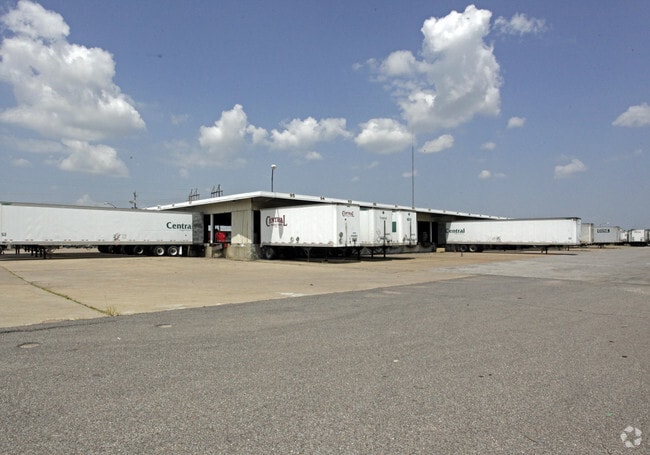
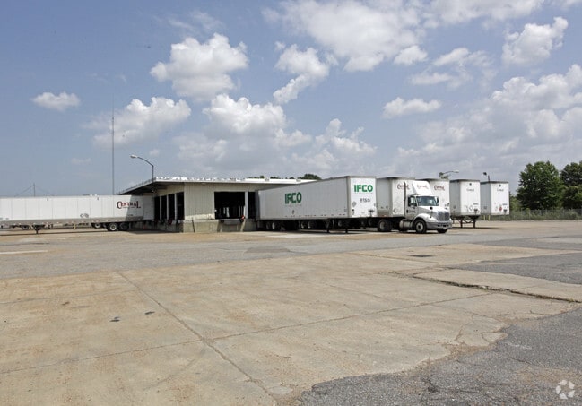
Truckterminal
Shelby
AE
Tennessee
47157C0430F
19&20
0
28.55 AC
2025
Southwest
022131
Memphis
68,748 SF
DEMOGRAPHICS near 1998 E Brooks Rd
1 mile
3 mile
5 mile
2024 Total Population
4,140
54,756
193,910
2029 Population
4,177
55,179
194,539
Pop Growth 2024-2029
+ 0.89%
+ 0.77%
+ 0.32%
Average Age
31
37
38
2024 Total Households
1,439
21,705
77,915
HH Growth 2024-2029
+ 0.69%
+ 0.73%
+ 0.21%
Median Household Inc
$31,785
$33,738
$37,409
Avg Household Size
2.80
2.40
2.40
2024 Avg HH Vehicles
1.00
1.00
1.00
Median Home Value
$83,627
$74,610
$86,064
Median Year Built
1962
1959
1959
Nearby Places
Map Layers
Map Styles
 Street
 Aerial
Transit
 Traffic
 Biking
Places
Listings with unknown addresses are not visible on the map
- Restaurants
- Banks
- Shops
- Fitness
- Groceries
PUBLIC TRANSPORTATION
COMMUTER RAIL
Central Station (Riverfront Loop - Memphis Area Transit Authority Trolley (MataTrolley))
Drive
Walk
Distance
Central Station (Riverfront Loop - Memphis Area Transit Authority Trolley (MataTrolley))
14 min
8.2 mi
AIRPORT
Memphis International
Drive
Walk
Distance
Memphis International
5 min
2.4 mi
Nearby Properties
Address
Land Use
TOTAL SIZE
Lot Size
Zoning
Address
Land Use
TOTAL SIZE
Lot Size
Zoning
386,565 SF
29.49 AC
IH
Address
Land Use
TOTAL SIZE
Lot Size
Zoning
180,831 SF
13.11 AC
EMP
Address
Land Use
TOTAL SIZE
Lot Size
Zoning
279,419 SF
172.07 AC
EMP
Address
Land Use
TOTAL SIZE
Lot Size
Zoning
357,582 SF
5.61 AC
EMP
Address
Land Use
TOTAL SIZE
Lot Size
Zoning
146,316 SF
18.07 AC
CMU-3
Address
Land Use
TOTAL SIZE
Lot Size
Zoning
105,841 SF
7.45 AC
IH
Address
Land Use
TOTAL SIZE
Lot Size
Zoning
144,078 SF
17.93 AC
RU-3
Address
Land Use
TOTAL SIZE
Lot Size
Zoning
38,600 SF
30.35 AC
RU-3
Address
Land Use
TOTAL SIZE
Lot Size
Zoning
2,847.82 AC
EMP
Address
Land Use
TOTAL SIZE
Lot Size
Zoning
345,806 SF
33.16 AC
RU-3
Address
Land Use
TOTAL SIZE
Lot Size
Zoning
253,883 SF
37.28 AC
IH
Address
Land Use
TOTAL SIZE
Lot Size
Zoning
47.65 AC
R-8
Address
Land Use
TOTAL SIZE
Lot Size
Zoning
14,075 SF
9.36 AC
RU-3
Address
Land Use
TOTAL SIZE
Lot Size
Zoning
214,950 SF
17.05 AC
CMU-2
Address
Land Use
TOTAL SIZE
Lot Size
Zoning
1,760,826 SF
109.47 AC
EMP
Address
Land Use
TOTAL SIZE
Lot Size
Zoning
81,454 SF
EMP
Address
Land Use
TOTAL SIZE
Lot Size
Zoning
509,111 SF
EMP
Address
Land Use
TOTAL SIZE
Lot Size
Zoning
52,347 SF
11.55 AC
R-8
Address
Land Use
TOTAL SIZE
Lot Size
Zoning
81,790 SF
17.82 AC
CMU-2
Address
Land Use
TOTAL SIZE
Lot Size
Zoning
342,605 SF
82.99 AC
CA
Address
Land Use
TOTAL SIZE
Lot Size
Zoning
1,117,337 SF
127.15 AC
EMP
Address
Land Use
TOTAL SIZE
Lot Size
Zoning
55,250 SF
7.15 AC
CMU-3
Address
Land Use
TOTAL SIZE
Lot Size
Zoning
165,227 SF
25.12 AC
RU-3
Address
Land Use
TOTAL SIZE
Lot Size
Zoning
71,308 SF
EMP
Address
Land Use
TOTAL SIZE
Lot Size
Zoning
66,841 SF
7.86 AC
CMU-3
Address
Land Use
TOTAL SIZE
Lot Size
Zoning
62,022 SF
6.28 AC
EMP
Address
Land Use
TOTAL SIZE
Lot Size
Zoning
42,102 SF
18.74 AC
RU-3
Address
Land Use
TOTAL SIZE
Lot Size
Zoning
209,257 SF
39.71 AC
EMP
Address
Land Use
TOTAL SIZE
Lot Size
Zoning
7,632 SF
40.80 AC
EMP
Address
Land Use
TOTAL SIZE
Lot Size
Zoning
203,086 SF
6.32 AC
IH
The World's #1 Commercial Real Estate Marketplace
Connect with us
© 2026 CoStar Group
The information above has been obtained from sources believed reliable. While we do not doubt its accuracy we have not verified it and make no guarantee, warranty or representation about it. It is your responsibility to independently confirm its accuracy and completeness. Any projections, opinions, assumptions, or estimates used are for example only and do not represent the current or future performance of the property. The value of this transaction to you depends on tax and other factors which should be evaluated by your tax, financial, and legal advisors. You and your advisors should conduct a careful, independent investigation of the property to determine to your satisfaction the suitability of the property for your needs.